Heatwave projections for Finland at different levels of global warming derived from CMIP6 simulations

Vol. 58, No. 1, 2023

Abstract

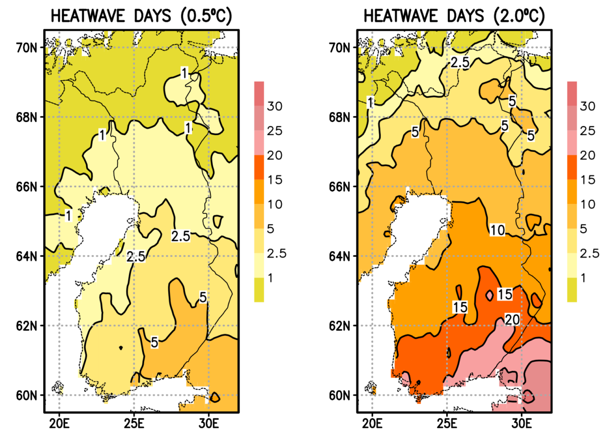
Even in the cool climate of Finland, severe heatwaves occur sporadically, having multiple implications on public health, forestry, fishery, agriculture, and reindeer husbandry, for instance. This study assesses the occurrence and severity of ≥ 3 -day heatwaves in Finland at the 0.5°C, 1.0°C, 1.5°C, and 2.0°C global warming levels above pre-industrial conditions, utilising bias-corrected daily-mean temperature data from 60 runs performed with 25 global climate models. The severity of a heatwave is measured by the heatwave extremity index, consisting of the sum of exceedances above a fixed threshold of daily mean temperature. Three alternative threshold temperatures, 20°C, 24°C and 28°C, are considered. A shift from the 0.5°C to 2.0°C global warming level is projected to result in an increase in the mean annual number of heatwave days above 20°C from 1 to 5 in central Lapland and from 5 to 20 in south-eastern Finland. Concurrently, the annual sum of the extremity index becomes 4 to 10 -fold. The higher the threshold temperature, the larger is the growth in relative terms. At the 2.0°C global warming level, heatwaves above 20°C are experienced in southern Finland nearly every year and in the majority of northern Lapland approximately every second year. Apart from Lapland, heatwaves occurring once in 10 (100) years at the 0.5°C warming level will then have annual probabilities of 50 % (> 10%). Even between the 1.5°C and 2.0°C global warming levels, projected changes in heatwave characteristics are substantial, especially for the most severe heatwaves. For example, in southern and centralFinland, a heatwave with an annual probability of 12 % to 13 % at the 1.5°C warming level is projected tosubstantially increase in likelihood under the 2.0°C warming level, up to 19 % to 21 %. The paper includes a literature review on potential impacts of the intensifying heatwaves.

Recent High-Order Global Geopotential Models for Geoid Modelling in Egypt

Vol. 58, No. 1, 2023

Abstract

An optimum Global Geopotential Model (GGM) is required either to represent the long wavelength of the Earth’s gravitational field in gravimetric geoid modelling or to act as a stand-alone national geoid in some developing countries. Thus, the current research aims to investigate the performance of seven recent high-order GGMs over Egypt utilizing the most recent precise Global Navigation Satellite Systems(GNSS)/Levelling datasets. Attained results showed that the investigated GGMs perform differently over Egypt with an accuracy level varying between ±0.249m for the SGG-UGM-1 model and ±0.300m for the GECO model. Removing outliers in the terrestrial dataset reveal significant improvements, in terms of standard deviations. Consequently, the performance of the investigated GGMs has been modified where the EIGEN-6C4 model became the best model with a standard deviation equals ±0.172m. Furthermore, a 3D spatial correction surface has been constructed and has been added to the original EIGEN-6C4 model to get an enhanced version of the global EIGEN-6C4. Over checkpoints, the average error of the enhanced model equals −0.018m with a standard deviation equal ±0.011m. That means that incorporating terrestrial geodetic data into the global EIGEN-6C4 model has increased its accuracy in Egypt by almost 36 %. Accordingly, such developed enhanced GGM represent the optimum stand-alone geoid model in Egypt. Nevertheless, such accuracy levels of GGMs do not fulfill the requirements of high-accuracy surveying and civil engineering applications. That concludes that a precise national geoid model is still crucial. It is recommended that all available geodetic datasets should be collected from all governmental and private organizations to construct a national geodetic database that would be implemented in modelling an Egyptian local geoid.

Use of Amplitudes in Velocity and Joint Velocity-Attenuation Surface Wave Geotomography

Vol. 58, No. 1, 2023

Abstract

In the past, geotomographic imaging of phase velocity using Rayleigh waves has mostly relied upon travel time data (or, equivalently, path-averaged phase velocity data). Over the last decade or two, the wide availability of observations from well-calibrated seismometers has enabled the use of surface wave amplitudes to supplement travel time data. Amplitudes vary in a heterogeneous Earth due to lensing effects, with high velocity patches leading to defocusing and lower amplitudes and low velocity patches leading to focusing and higher amplitudes. Amplitude data complements travel time data, because while the latter is due to the phase velocity along the propagation path, the former is due to the second derivative of phase velocity perpendicular to it. In this study, we quantify the benefit of supplementing traditional travel time geotomography with amplitude data. Key to our formulation is the representation of the spatially-varying phase velocity using cubic splines, which allow second derivatives to be stably and efficiently computed. We find that high-quality (10 : 1 signal-to-noise ratio) amplitude data improves recovery of the phase velocity by 95 % and poor-quality (1 : 1 s.n.r.) by 75 %. Furthermore, the improvement is excellent irrespective of whether the azimuthal coverage of sources is poor or good, and irrespective of whether the data are sparse and the problem underdetermined, or plentiful and overdetermined. We also examine the viability of a joint inversion for phase velocity and intrinsic attenuation factor. This problem is not as well-behaved as the velocity-only one. Its sensitivity to amplitude noise is higher, with 1 % amplitude noise leading to up to 4 % phase velocity error; furthermore, the attenuation factor is well-recovered only when the problem is overdetermined. A squeezing analysis indicates that phase velocity and attenuation factor can significantly trade off.

Welcome to the new Geophysica website. Articles published before 2019 are temporarily accessible only through our archived old site.